Construction Project Updates Map
About the Map & How to Use It:
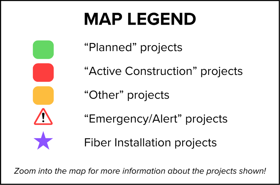
Our Map Legend is color-coded to show construction projects that are planned, in active construction, and 3rd party projects that we don't have all the details about.
Green projects have been approved by our City Council, bid out to contractors, and are awaiting start date.
Red projects are under active construction. These are the projects that are currently impacting traffic and have the potential to cause delays and/or detours. Be sure to watch these projects on the map for detour locations.
Yellow projects are ones that our team is aware of, but they do not fall under our complete purview. We don't have specific information about start and end dates or projections, but we are aware of planned work this year in that area. As details become available we will update the map accordingly.
Alerts: against all of our best efforts, emergencies do happen. If something like a sewer or water line should rupture and an area is affected, we'll mark them on this map with an "!" so residents can know exactly who and where is affected.
Silver Star Construction: we intend to work with the Silver Star Communications' construction team to mark areas where fiber broadband installations are imminent. We understand their construction crews will be focusing on extending this access in the southeast parts of the city in 2025; mostly neighborhoods on the hill.
As you scroll into the map, the dashed lines that surround the project area will show more specific solid-colored areas that will be affected during construction.
You can click on any of the projects throughout the map to learn
What we're doing
When we anticipate construction to start
How the project may impact travel and
How long the project is planned to be in effect
PLEASE NOTE:
Other projects outside of the City's oversight may also create road obstructions. While our intent is to include those here as much as we can, we are not privy to all of the information surrounding these projects - i.e. specific start and end dates.
Slurry & Chip Seals: As the season progresses, some projects will pop up that are short-term projects, like slurry and chip seals. Residents should expect this particular project to take place on roadways that were newly laid in 2024. We anticipate short-term (one-day) closures in small areas at a time for these projects to take place. We have been advised to watch for these projects in mid-July and August. We will try to add these to the map as they become relevant, however the short-term of them may restrict our ability to share them with advanced notice.
We appreciate your patience during this very productive construction season.
Diverging Diamond Interchanges
In 2024, the Idaho Transportation Department (ITD) reconstructed the south and central exits with Diverging Diamond Interchanges (DDIs). The North interchange had a permanent traffic light installed.
As the summer of 2025 approaches, cosmetic updates are expected to take place as well as final details, i.e. chip/slurry seal, line painting, and signage. There may be brief traffic interruptions to the interchanges during these times, but projects are not expected to be nearly as significant as last year's complete redesign.
How do DDIs work?
This video describes why DDIs were planned for Rexburg interchanges, what a DDI is, and how they work. (Skip to 1:14 for a helpful instructional animation.)
Preparation for the new Rexburg LDS Temple
With the announcement of a new LDS Temple going in on the North end of 2nd E (through Moody Rd), many infrastructure improvements have been slated for the are along that route that will be affecting traffic on that road. Projects include:
Sewer & water upgrades
Widening of 2nd E to a 5-lane road
Signal upgrade at the North HWY 20 interchange
Curb and gutter upgrades
This multi-year project began in 2024. Infrastructure upgrades will continue through the 2025 season.